
- Home »
- Bhutan »
- Bhutan Tours & Treks »
- Wild East Rodung La Trek
Overview & Highlights
Trip Facts
- Max Elevation3680m
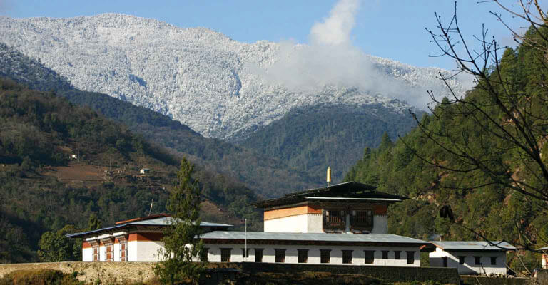
While the Rodung La Trek does not ascend to very high altitudes, it is still fairly challenging as the trail covers some fairly steep climbs and descents. The trail takes you from Bumthang in Central Bhutan to Trashiyangtse in the far eastern reaches of the kingdom.
The route was once an important trade road in the past but has fallen into disuse now and is chiefly used as a hiking trail. The trail passes through alpine and bamboo forests, meadows and mountain passes, through villages and temples offering hikers an incredible array of biodiversity to appreciate. The Hike typically takes 10 days to complete and is best carried out in winter between October-Early November or in spring between April-Early May.
Itinerary
Explore the day-by-day plan for your journey.
Distance 20 km, 6-7 hours, camp altitude 2,800 m. The route takes you around Chamkhar Chhu, a river rich in trout. After passing Thangbi Lhakhang, a temple built by the first Karma Shamar in 13th century you will enter Ngang Yul or ‘Swan Land” named for the swans that were once common in this…
Food
BLD
Accommodation
Tented Camp
Elevation
2800 m.
Camp altitude 2,850 m. You begin with a gradual climb to Phephe La pass (3,353m). Follow the trail until the pass takes you through a picturesque forested region. It is recommended that you allow for stops along the way to enjoy the natural beauty of the surroundings. You will stop for the ni…
Food
BLD
Accommodation
Tented Camp
Elevation
2850 m.
Distance 17 km, 5-6 hours, 920 m ascent, camp altitude 3,680 m. Today’s walk is through bamboos, hemlock and finally up to an alpine forest. The camp is in a meadow at the head of the valley.
Food
BLD
Accommodation
Tented Camp
Elevation
3680 m.
Distance 20 km, 6-7 hours, 480 m ascent, 1,160 m descent, camp altitude 2,950 m. Rodung La (4,160m) is about three hours climb from the camp. From the pass you then continue downhill through a gorge, overlooking scenic mountain valleys covered in lush pine forests. The region is rich in folk …
Food
BLD
Accommodation
Tented Camp
Elevation
2950 m.
Distance 21 km, 7-8 hours, 350 m ascent, 1,340 m descent, camp altitude 2,010 m. This trail winds through the villages of Ungaar, Bulay, Kulaypang and Gomda before bringing you to Drula village and Khaine Lhakhang. One of the oldest temples in the country, it was built in the mid 7th century …
Food
BLD
Accommodation
Tented Camp
Elevation
2010 m.
Distance 18 km, 6-7 hours, 520 m ascent, 810 m descent, camp altitude 1,720 m. From your camp, the trail goes down to a stream and back up to a basic health unit and a community school in Gorsam. Further on, you pass a Tibetan-style Umling Mani, built by a lama from Tibet, and a chorten on Ze…
Food
BLD
Accommodation
Tented Camp
Elevation
1720 m.
Distance 16 km, 4-5 hours, 690 m ascent, 620 m descent, camp altitude 1,830 m. After arriving at Kuri Zampa the trek begins to gradually climb up through paddy fields and villages before bringing you to Chusa.
Food
BLD
Accommodation
Tented Camp
Elevation
1830 m.
Distance 20 km, 5-6 hours, 620 m ascent, camp altitude 2,450 m. Today’s trek has you continue uphill through thick forests overlooking spectacular mountains. The camp is located in a forested area at an altitude of 2,400m.
Food
BLD
Accommodation
Tented Camp
Elevation
2450 m.
Distance 21 km, 7-8 hours, 1,450 m ascent, 1,450 m descent, camp altitude 2,450 m. After climbing up to Dongla you will descend through thick evergreen forests until you reach the campsite for the night.
Food
BLD
Accommodation
Tented Camp
Elevation
2450 m.
Distance 24 km, 8-9 hours, 720 m descent. Today is the longest day of the trek. It is a gradual descent to Trashi Yangtse. As you descend the chirpine and hardwood forests are slowly replaced by oak trees. The final camp of the trek is located in a subtropical forested region.
Food
BLD
Altitude & route map
Select a preview for a full-width, zoomable view.
Wild East Rodung La Trek Altitude Profile
Trip visual
Similar Trips
Enjoy the popular trekking and tour packages in Nepal Himalayas. 2026.
Samtengang Winter Trek
Punakha Winter Trek
Merak Sakteng Trek
Jomolhari Loop
Jomolhari Laya Gasa Trek
Gangtey Trek