.jpg)
Overview And Highlights
TRIP FACTS

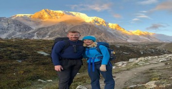
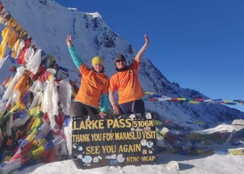
The 10 Days Manaslu Circuit Trek offers a thrilling Himalayan adventure into one of Nepal’s most untouched trekking regions. Encircling the majestic Mount Manaslu (8,163m), the world’s eighth-highest peak, this route takes you through authentic Tibetan-influenced villages, deep gorges, pristine river valleys, and over the awe-inspiring Larke La Pass (5,106m).
Unlike the crowded Annapurna and Everest regions, the Manaslu Circuit remains a relatively less-traveled gem, rich in biodiversity and cultural depth. In just 10 days, this itinerary offers the full trekking experience—from subtropical hills to alpine landscapes, dense pine forests to windswept passes. It’s a moderate to challenging trek, perfect for fit adventurers who seek off-the-beaten-path experiences.
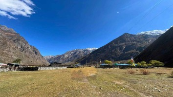
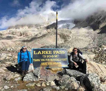
Starting with a scenic drive from Kathmandu to Machha Khola, the journey unfolds along the Budi Gandaki River, ascending gradually through Jagat, Deng, Namrung, and Samagaon—a beautiful village that serves as an acclimatization stop and base for day hikes to Manaslu Base Camp or Pungyen Gompa. After crossing Samdo and Dharamshala, the trek culminates in a dramatic crossing of Larke Pass, offering views of Himlung Himal, Cheo Himal, Kang Guru, and Annapurna II.
The descent through Bimtang to Dharapani is equally spectacular, eventually ending with a drive back to Kathmandu. This short version packs all the dramatic elements of the Manaslu trek into a 10-day frame, ideal for 2025 and 2026 travelers with limited time but high adventure spirits.
Trip Highlights
-
Remote and culturally rich trek around Mt. Manaslu
-
Less crowded trail with authentic Himalayan experience
-
Scenic landscapes: rivers, forests, glaciers, and high passes
-
Tibetan-influenced Buddhist villages and monasteries
-
Epic views from Larke La Pass (5,106m)
-
Ideal for fit trekkers seeking off-the-beaten-path treks
Best Seasons for Manaslu Circuit Trek
| Season | Months | Weather Condition | Highlights |
|---|---|---|---|
| Spring | March to May | Clear skies, warm | Rhododendron blooms, ideal weather |
| Autumn | September to Nov | Stable, dry | Crisp air, best mountain visibility |
| Winter | Dec to Feb | Cold, snowy | Quiet trails, but Larke Pass may close |
| Monsoon | June to August | Wet, slippery | Not recommended due to landslides |
What to Pack for Manaslu Circuit Trek
Clothing
-
Moisture-wicking base layers
-
Fleece or insulated mid-layer
-
Waterproof and windproof jacket
-
Trekking pants & thermal leggings
-
Down jacket (for high altitude)
-
Gloves, wool hat, buff/scarf
Footwear
-
Waterproof trekking boots (broken in)
-
Camp sandals/shoes
-
Warm socks (woolen and synthetic)
Gear & Accessories
-
Sleeping bag (-15°C rated)
-
Day backpack (30-40L)
-
Trekking poles
-
Sunglasses with UV protection
-
Headlamp with extra batteries
-
Water purification tablets or bottle
-
Power bank & charging cables
Personal Items
-
Sunscreen (SPF 30+)
-
Lip balm, toiletries
-
First aid kit & personal medication
-
Passport, permits, cash (no ATMs)
Itinerary Expand All Close All
-
Distance: 170 km
-
Duration: 9–10 hours
-
Mode: Private jeep or shared vehicle
Start your journey early from Kathmandu and embark on a long yet scenic drive through Dhading and Arughat to reach Machha Khola. The route offers panoramic views of hills, rivers, terraced farms, and villages. Overnight in a teahouse at Machha Khola near the banks of the Budi Gandaki River.
Food
BLD
Accomodation
Teahouse
Elevation
900
-
Distance: 22 km
-
Duration: 6–7 hours
The trail today follows the Budi Gandaki River valley, crossing suspension bridges, lush forests, and small settlements. Pass through Tatopani (hot spring area) and Dovan before ascending to the stone-paved village of Jagat—a checkpoint for entering the restricted Manaslu region.
Food
BLD
Accomodation
Teahouse
Elevation
1410
-
Distance: 20 km
-
Duration: 6–7 hours
Ascend gradually through the narrow gorge, terraced hillsides, and charming Gurung villages. Cross the river multiple times, traverse through forested paths, and continue to the culturally rich village of Deng. The trail today starts revealing hints of Tibetan influence.
Food
BLD
Accomodation
Teahouse
Elevation
1804
-
Distance: 19.5 km
-
Duration: 6–7 hours
Today’s trail climbs steeply through pine and fir forests, with spectacular views of snow-capped peaks and deep river valleys. Pass through the picturesque villages of Rana, Bihi Phedi, and Ghap before reaching the fortified stone village of Namrung, offering a first real glimpse of Mt. Manaslu.
Food
BLD
Accomodation
Teahouse
Elevation
2630
-
Distance: 18 km
-
Duration: 6–7 hours
This is one of the most scenic days of the trek. Traverse through the traditional Tibetan-influenced villages of Lho and Shyala, with panoramic views of Manaslu, Himal Chuli, and Ganesh Himal. Reach Samagaun, a large and culturally significant village, nestled below Mt. Manaslu.
Food
BLD
Accomodation
Teahouse
Elevation
3530
-
Distance: 7.5 km
-
Duration: 3–4 hours
A short and gradual trek across yak pastures and mani walls leads to Samdo—a remote village near the Tibetan border. This area is excellent for observing Tibetan refugee culture and local herding practices.
Food
BLD
Accomodation
Teahouse
Elevation
3800
-
Distance: 6.5 km
-
Duration: 3–4 hours
Today’s trek ascends gently to Larke Phedi, also known as Dharamshala. It's a small settlement used as a base before crossing the Larke Pass. Use the afternoon to rest, hydrate, and prepare for the longest and highest pass crossing the next day.
Food
BLD
Accomodation
Teahouse
Elevation
4460
-
Distance: 24.5 km
-
Duration: 8–9 hours
Start early to cross Larke La Pass (5,106m)—the most challenging and rewarding part of the trek. Expect stunning panoramic views of Himlung Himal, Cheo Himal, Kang Guru, and Annapurna II. After crossing the pass, descend through glacial moraines and snowy trails to Bimtang.
Food
BLD
Accomodation
Teahouse
Elevation
5106
-
Distance: 23 km
-
Duration: 7–8 hours
Descend steeply through rhododendron forests, pasturelands, and several small villages such as Gho and Tilije. Reach Dharapani, a gateway village that intersects with the Annapurna Circuit trail. Overnight at a comfortable lodge.
Food
BLD
Accomodation
Teahouse
Elevation
1860
-
Distance: ~200 km
-
Duration: 9–10 hours by private jeep
After breakfast, drive through the Marsyangdi Valley toward Besisahar and onward to Kathmandu or Pokhara. End of the trek with unforgettable memories of the majestic Manaslu region.
Food
BLD
Accomodation
Teahouse
Services Included on Price
Cost Includes
-
Accommodation
-
Tea house/lodge stays during trek (basic, twin-sharing)
-
-
Transport
-
Local bus Kathmandu → Soti Khola (trek start)
-
Local jeep Dharapani → Besisahar
-
Local bus Besisahar → Kathmandu
-
Airport pick-up in Kathmandu
-
-
Meals
-
Not included – trekkers pay directly at lodges
-
-
Guide & Porter
-
Licensed, English-speaking trekking guide (mandatory for restricted area)
-
No porter service (optional at extra cost)
-
-
Permits & Fees
-
Manaslu Restricted Area Permit (RAP)
-
Manaslu Conservation Area Permit (MCAP)
-
Annapurna Conservation Area Permit (ACAP)
-
-
Extras
-
Pre-trek briefing in Kathmandu
-
Basic first aid kit with guide
-
Cost Excludes
-
Meals in Kathmandu & during trek
-
Hotel accommodation in Kathmandu
-
Porter service (optional)
-
Personal trekking gear (jacket, poles, sleeping bag, etc.)
-
Hot showers, Wi-Fi, charging in lodges (paid locally)
-
Travel insurance (mandatory)
-
International airfare & Nepal visa fees
-
Alcohol, bottled water, snacks
-
Tips for guide, porter, driver
-
Costs due to delays/weather/natural disasters
Standard Package Service Includes
-
Accommodation
-
2 nights in 3★ hotel in Kathmandu with breakfast
-
Tea house/lodge stays during trek (twin-sharing)
-
-
Transport
-
Private Jeep Kathmandu → Soti Khola
-
Private jeep Dharapani → Besisahar
-
Tourist bus Besisahar → Kathmandu
-
Airport transfers in Kathmandu
-
-
Meals
-
Breakfast in Kathmandu hotel
-
All meals during trek (breakfast, lunch, dinner with tea/coffee)
-
-
Guide & Porter
-
Licensed, English-speaking trekking guide
-
Porter service (1 porter for 2 trekkers, 15–20 kg)
-
-
Permits & Fees
-
Manaslu Restricted Area Permit (RAP)
-
Manaslu Conservation Area Permit (MCAP)
-
Annapurna Conservation Area Permit (ACAP)
-
-
Extras
-
Pre-trek briefing
-
First aid kit with oximeter
-
Standard Package Service Excludes
-
Lunch & dinner in Kathmandu
-
Personal trekking equipment (rentable in Kathmandu)
-
Hot showers, Wi-Fi, charging in lodges (paid locally)
-
Travel insurance
-
International airfare & Nepal visa fees
-
Alcohol, bottled water, snacks
-
Tips for guide, porter, driver
-
Extra costs due to delays/weathe
Luxury Package Service Includes
-
Accommodation
-
2 nights in 4–5★ hotel in Kathmandu with breakfast
-
Best available lodges during trek (attached bathroom where possible)
-
-
Transport
-
Private jeep Kathmandu → Soti Khola
-
Private jeep Dharapani → Kathmandu (direct, more comfortable)
-
Luxury transfers in Kathmandu
-
Welcome & farewell dinners in Kathmandu
-
-
Meals
-
All meals during trek with wide menu options
-
Breakfast in Kathmandu hotel
-
Welcome & farewell cultural dinners
-
-
Guide & Porter
-
Senior trekking guide (restricted area experienced)
-
Porter service (20–25 kg per porter)
-
Staff insurance included
-
-
Permits & Fees
-
Manaslu Restricted Area Permit (RAP)
-
Manaslu Conservation Area Permit (MCAP)
-
Annapurna Conservation Area Permit (ACAP)
-
-
Extras
-
Loaner trekking gear (sleeping bag, down jacket, trekking poles)
-
Emergency evacuation coordination (insurance required)
-
Daily health monitoring with oximeter
-
Cultural sightseeing in Kathmandu (optional add-on)
-
Luxury Package Service Excludes
-
International airfare
-
Nepal visa fees
-
Comprehensive travel insurance
-
Personal expenses (souvenirs, laundry, phone calls)
-
Alcohol, bottled water, soft drinks
-
Tips for guide, porter, driver
-
Optional upgrades (helicopter, single supplement)
-
Costs due to delays/weather/natural disasters
10 Days Manaslu Circuit Trek Altitude Profile
FAQs
-
Not recommended for beginners; best for experienced or fit trekkers.
-
Yes, it’s mandatory to trek with a guide in the Manaslu region due to its restricted area status.
-
It’s moderately challenging; early morning starts and proper acclimatization are crucial.
-
Yes, you’ll need a Manaslu RAP, MCAP, ACAP, and TIMS card.
-
Yes, at most teahouses (solar/electricity), but expect extra charges.
-
Limited. Wi-Fi is available at some lodges with cost.
-
Mostly Nepali/continental meals like dal bhat, noodles, pasta, soups, eggs.
-
Yes, with coverage for evacuation above 5,000m.
-
Boiled water and purification tablets/bottles are recommended.
-
Spring (Mar–May) and Autumn (Sep–Nov) offer the best weather.
-
Yes, but can be prevented with proper pacing and acclimatization.
-
Yes, Annapurna Encounter offers fully customizable itineraries.
-
2 to 10 trekkers, but private trips can be arranged.
-
Roughly 140–160 km depending on acclimatization side hikes.
-
No, it's less crowded than Everest or Annapurna routes.
-
Basic teahouses and lodges along the trail.
-
As low as -10°C to -15°C at high altitudes in autumn/spring.
-
Yes, Annapurna Encounter provides secure luggage storage.
- Be cautious of altitude, drink clean water, and carry basic meds.
.jpg)
.jpg)
.jpg)
.jpg)
.jpg)
.jpg)